UK weather – today: Snow forecast issued by Met Office as temperatures plummet across UK
Temperatures are expected to plunge, bringing snow to parts of the UK amid yellow warnings for strong winds of up to 55 mph

Sign up to the Independent Climate email for the latest advice on saving the planet
Get our free Climate email
Temperatures are expected to plunge into the weekend and through the week with temperatures becoming chillier, bringing rain, hail, sleet and snow to parts of the UK.
Most snow is likely to hit northern parts of the UK, with some central parts also affected.
This comes as the Met Office issues three yellow weather warnings for strong winds across parts of Northern Ireland, northwest Wales and England, which are expected to bring widespread disruption to transport and infrastructure.
Gusts up to 55mph are likely for many, with the worst affected areas of England to include Blackpool, Cumbria, Lancashire and Merseyside.
Country Antrim and and Conwy are to be the worst affected in Northern Ireland and Wales respectively, with 70 mph gusts also possible for areas with exposed coasts and hills.
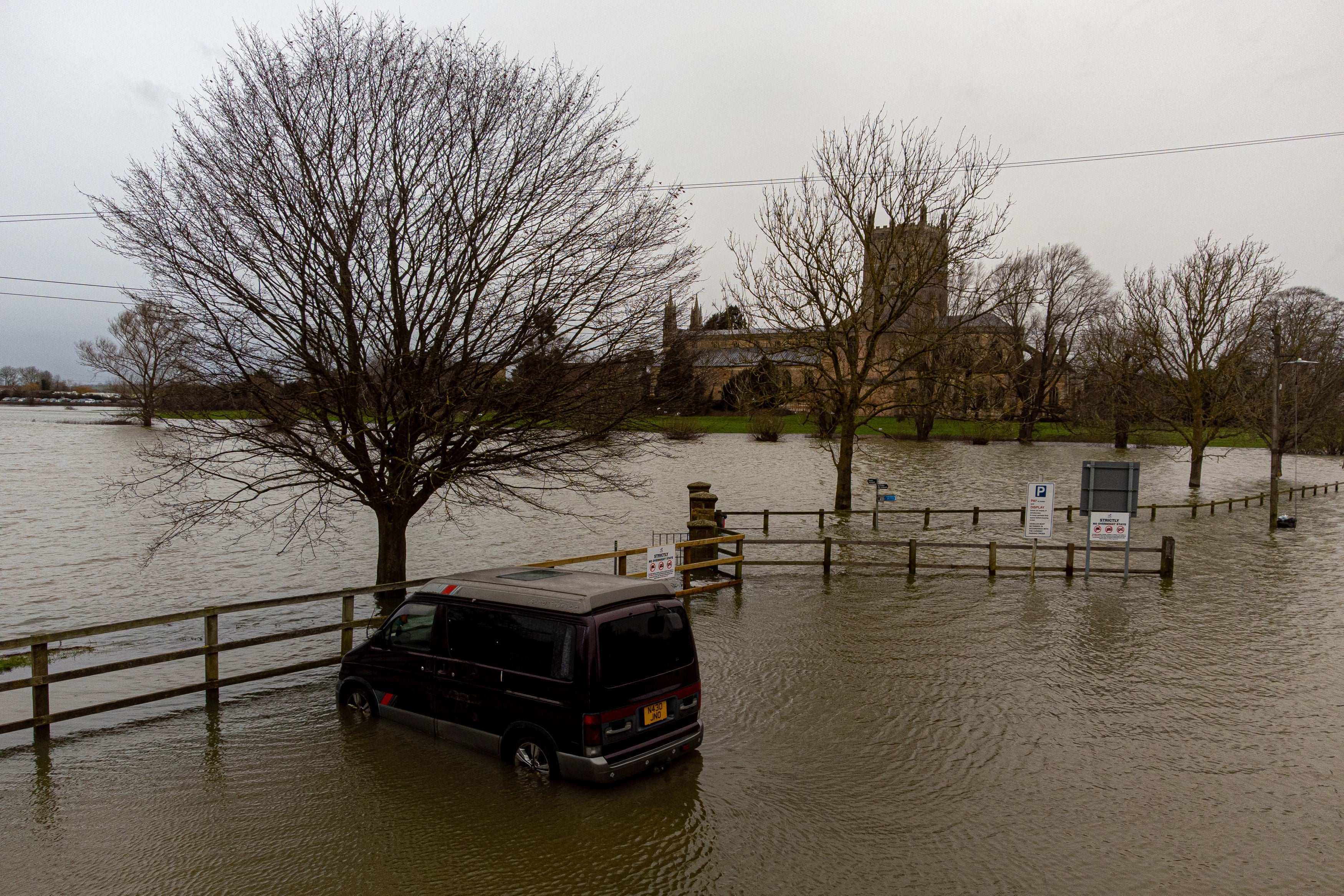
Hundreds of flood alerts have been cautioned in England by the Environment Agency after relentless rain left towns and other residential areas under several feet of water.
Images and videos have captured how settlements across the southwest have been effectively transformed into islands after the River Severn burst its banks following days of torrential rain.
Meteorologist Aidan McGivern said: “It’s going to stay blustery, with some strong gusts in the west in particular and these lows will continue to send us outbreaks of rain and showers heading into the weekend.”


Winter temperature records broken across Europe just days into 2023
Winter temperatures have hit record highs across Europe already this month, as conditions have warmed up following December’s cold snap.
Eight countries have seen record national highs, with regional records in another three areas.
The start of the new year in Warsaw, Poland hit 18.9C on Sunday while it was 25.1C in Bilbao, Spain, the latter of which is 10C warmer than average for the time of year.
Lucy Skoulding reports:

Winter temperature records broken across Europe just days into 2023
Eight countries have had national temperature records broken, with Spain experiencing 25C heat in the first week of January
How to check for flood alerts and warnings in your area
A number of new flood warnings have been issued in recent days as a band of rainwater and strong gales pushed eastwards across England and Wales, further threatening to disrupt travel after a month of rail and road strikes.
The Met Office has issued a new yellow weather warning of heavy rain for northwest England and central Wales on Tuesday, saying that between 60 and 80mm could fall between 6am and 8pm and warning of possible flooding.
If you are seeking to get ahead of the weather this winter, you can check all the latest flood alerts and warnings in your area on the government’s website simply by entering your postcode here.
Joe Sommerlad has more:

How to check for flood alerts and warnings in your area
UK hit by heavy rain throughout January after freezing December
Met Office five day outlook
Wednesday evening and night:
Rain moving eastwards across Northern Ireland, Wales, and England, heavy at times with a risk of flooding in the west. Windy in the south with coastal gales. Showers across Scotland dying out, leaving clearing skies and a patchy frost.
Thursday:
Further rain moving eastwards, heavy in places. Turning brighter from the west but with blustery showers, frequent and heavy in the northwest where gales or severe gales are likely.
Outlook for Friday to Sunday:
Remaining unsettled with further spells of rain and strong winds. Mostly mild at first, but turning somewhat colder through the weekend.
Heavy rain and flood warnings as downpours to lash England and Wales for 20 hours
England and Wales are set to be lashed by persistent heavy rain, with three days of warnings issued by the Met Office.
Scores of flood warnings and alerts are already in place for large parts of the country, with more downpours on the way this week.
Yellow weather warnings are already in place for north west England and parts of Wales and Scotland until 8pm on Monday.
My colleague Daniel Reast reports:

Flood warnings as England and Wales to be lashed by heavy rain for 20 hours
Met Office weather warnings for rain have been issued for areas across England and Wales
Watch: Cricket grounds completely submerged by floodwater after heavy downpour
In pictures: Flood waters around Tewkesbury


Temperatures to dip at weekend
The Met Office says temperatures will dip through the weekend and into next week, with the jet stream one of the driving forces behind this change.
Speaking in the Met Office 10-Day Trend, Meteorologist and Presenter Aidan McGivern said: “Next week, the jet stream is a bit more amplified and it’s coming at the UK from the northwest rather than from the west like recent days. This subtle change into the start of next week will see colder weather coming in and rather than prolonged bouts of rain from the west, we’re likely to see rain and showers coming from the northwest.
“These showers from the north could fall as snow over the high parts of Scotland, northern England and Northern Ireland later in the weekend, and as we move through next week often below average temperatures could support a mixture of rain, hail sleet and snow. Most of any snow accumulation is likely over higher parts of the northern UK.
“However, at this point significant differences in the computer models emerge. Most solutions lead to some unsettled weather, but the distribution of the rainfall and where we’re likely to see any snow varies as well. On Tuesday next week, the greatest risk of snow will be across northern parts of the UK, perhaps central areas and mostly over the hills.”
Brecon Beacons and Exmoor to experience wettest weather, say forecasters
More now from the Met Office 10-Day Trend:
Aidan McGivern continued: “With all that wet weather coming in, there are concerns, particularly for those areas that have already seen so much rain across western England and Wales. The wettest weather is likely to see 60-80mm falling across the Brecon Beacons and Exmoor.”
Further persistent rain will move in on Friday night and into Saturday, with the focus for the heaviest rain likely to be further north, including north Wales, northern England and Scotland, though many areas will still see periods of rain into the weekend
Wet and windy weather to continue into weekend
Wet and windy conditions will continue to dominate as we head towards the weekend, thanks largely to the position of the jet stream, forecasters have said.
Speaking in the Met Office 10-Day Trend, Meteorologist and Presenter Aidan McGivern said: “The jet stream is approaching the UK from the west and sending us further areas of low pressure, with tightly packed isobars across the UK. That continues to be the case as further low-pressure systems deepen and get sent in from the west.
“It’s going to stay blustery, with some strong gusts in the west in particular and these lows will continue to send us outbreaks of rain and showers heading into the weekend.”
Subscribe to Independent Premium to bookmark this article
Want to bookmark your favourite articles and stories to read or reference later? Start your Independent Premium subscription today.
Join our commenting forum
Join thought-provoking conversations, follow other Independent readers and see their replies
Comments